Kanchanjanga Circuit Trekking
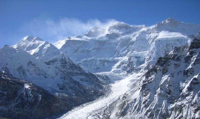
Kanchenjunga’ means ‘the five treasure houses of snow’, which gives you some idea of what to expect should you visit this area. At 8586 m, massive Kanchanjanga is the world’s third highest mountain, and marks the eastern border of Nepal with the Indian state of Sikkim. The conservation area that surrounds it extends into protected areas in Sikkim and Tibet, and comprises a beautiful, unspoilt wilderness. This is Snow Leopard territory, but the reclusive predator shares the unbounded forests with the Himalayan Black Bear and the Assamese Macaque, among others. Cascading waterfalls, lush vegetation and thousands of species of plants await those who take the long trail to Kanchenjunga Base Camp, the main route which has been described as ‘untrekked’.
Unabashedly wild, Kanchanjanga is for the true adventurer within you. The east of Nepal is more developed than the west, but the remoteness of this terrain, its rugged trails, scattered human habitation, and monsoonal downpours make for a perfectly challenging Trail. Wending slowly up through Ghunsa for views of Kanchenjunga’s massive north face, you will reach base camp at Pangpema, then push on to Jhinsing La, the starting point of the Trail.
Along the way, you will walk along paths used mostly by locals, as very few trekkers make their way to the wild east of Nepal. For those who do, the reward lies in more than just the breathtaking views of Kanchenjunga and its companions. Like neighbouring Makalu Barun, the region endures the full force of the monsoon and is consequently bursting with life. Over 2000 different flowering plants have been recorded here, and you’ll see some of the richest rhododendron forests in Nepal. New species are still being discovered in the pristine forests!
The east of Nepal also provides a fascinating introduction to its cultural diversity. The villages tend to be more prosperous than elsewhere in Nepal, but the further you go the more isolated the communities. An easy way to make friends is to join the locals for a heart-warming drink of hot tongba, the fermented millet drink of the east.
Facts of the Trek
| Grade | Strenous |
|---|---|
| Per day walking | 6-7 hours |
| Type of Trek | Teahouse/camping |
| Duration | 27 days |
| Max elevation | 5388m |
Itinerary
Day 01 Arrival in Kathmandu
Day 02 Sightseeing in Kathmandu and trekking preparation
Day 03 Fly from Kathmandu to Biratnagar (81m)
Day 04 Fly from Biratnagar to Suketar (1179m)
Day 05 Suketar to Mitlung (921m) 4-5 hrs
Day 06 Mitlung to Chirwa (1270m) 5-6 hrs
Day 07 Chirwa to Sukathum (1576m) 5-6 hrs
Day 08 Sukathum to Amjilosa (2308m) 6-7 hrs
Day 09 Amjilosa to Gyabla (2730m) 6-7 hrs
Day 10 Gyabla to Ghunsa (3595m) 5-6 hrs
Day 11 Rest day, acclimatization at Ghunsa
Day 12 Ghunsa to Kambachen (4050m) 5-6 hrs
Day 13 Acclimatization at Kambachen
Day 14 Kambachen to Lhonak (4780m) 6-7 hrs
Day 15 Trek to Pangpema/Kanchanjanga North Base camp (5388m) 6-7 hrs
Day 16 Trek back to Kambachen (4050m) 6-7 hrs
Day 17 Kambachen to Ghunsa (3595m) 3-4 hrs
Day 18 Ghunsa to Sele Le (4290m) 6-7 hrs
Day 19 Sele Le to Cheram (3870m) 6-7 hrs
Day 20 Cheram to Ramche (4580m) 4-5 hrs
Day 21 Cheram to Tortong (2995m) 5-6 hrs
Day 22 Tortong to Yamphudin (2080m) 6-7 hrs
Day 23 Yamphudin to Yangpang (1007m) 6-7 hrs
Day 24 Yangpang to Thorpu (1500m) 5-6 hrs
Day 25 Thorpu to Birtamod (300m) 5-6 hrs
Day 26 Drive from Birtamod to Bhadrpur then fly to Kathmandu
Day 27 Farewell
Itinerary Outline
(Please Note: If the above schedule does not meet your need and interest,we can design individualized travel plans based on your preferences.)
Social Share